Busan’s Sasang–Haeundae Expressway Will Reshape the Dongseo Corridor
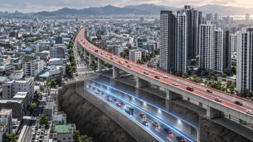
Busan is preparing a 21.7-kilometer underground expressway between Sasang and Haeundae. The tunnel is increasingly defined, but its performance — and the future of the Dongseo Elevated Road above it — will depend on access points, tolls, ground conditions and the streets that remain.

Tracker · Ongoing
What we're tracking
How will the Sasang–Haeundae Expressway change traffic and the Dongseo corridor above it?
Where it stands
The 21.7-kilometer underground expressway is planned with five access facilities, with construction targeted for 2028 and completion for 2033. Busan has not yet settled the future of roughly five kilometers of the Dongseo Elevated Road that construction does not require it to remove.
What to watch
- Busan's decision on demolition, retention or reuse along the remaining Dongseo Elevated Road corridor
- The final toll and the detailed performance of the expressway's entrances, exits and surface connections
The 21.7-kilometer road is increasingly defined underground. Above it, Busan still has to decide how much road capacity to keep, how the old elevated structure should change and how western Busan’s ground and street network will absorb the project.
Busan’s next major east–west road is being designed mostly out of sight. The Sasang–Haeundae Expressway is planned to run 21.7 kilometers across the city, most of it underground, with five access facilities connecting the tunnel to the road network above. The project is estimated at 2.5128 trillion won, with construction targeted for 2028 and completion for 2033.
Part of the route follows the Dongseo Elevated Road, which has carried traffic from western Busan toward the center since the early 1990s. About 2.2 kilometers of the elevated structure are expected to be removed because construction of the underground road requires it. Roughly five kilometers farther along the corridor are different: construction itself does not require Busan to eliminate the entire stretch, leaving demolition, retention and possible reuse to a broader public and policy process. One decision follows from building the expressway; the other concerns what the surface corridor should become once another east–west route is available.
The geography explains why the city has returned repeatedly to this problem. Western Busan is organized around the Nakdonggang River, industrial districts, Gimhae International Airport and road links toward Gimhae and Changwon. Denser central districts and the Haeundae–Centum area lie farther east, across a city where mountains and heavily developed valleys limit the number of corridors capable of carrying large volumes of cross-city traffic. A tunnel can provide a continuous high-speed route beneath those obstacles, but every trip still begins and ends on the surface, where the amount of traffic that actually shifts underground will help determine what Busan can change above it.
The elevated road still carries the city
The Dongseo Elevated Road was built for an earlier version of Busan. Construction began in the late 1980s, when Sasang had become one of the city’s principal manufacturing districts and the industrial west needed more direct road access to central Busan and the regional highway network. The road opened in stages before full completion in 1994, adding capacity above an existing urban corridor instead of requiring the city to clear an entirely new route at ground level. Vehicles could pass over many intersections below while local streets continued to serve factories, residents and neighborhood businesses.
The design solved a transportation problem by fixing a large piece of infrastructure into the districts underneath it. Columns and ramps occupied street space; noise and shadow became part of the surrounding environment. Yet the transport function did not disappear as Busan changed around it. Tolls were abolished in 2009, express buses later began using the elevated road, and recent city traffic surveys have continued to record more than 80,000 vehicles a day.
Sasang also remains an industrial district rather than a place where manufacturing has already receded into history. Its 2024 business survey shows a large manufacturing base within a district that now also contains dense residential, commercial and transport functions. Factories and warehouses share Sasang with apartments, subway stations and regional transport facilities, even as its residential population has declined and aged.
Travel across the wider metropolitan area has become more complicated at the same time. Western Busan is tied to the center and east, but important movements also extend toward Gimhae and Changwon, while central and eastern Busan contain their own large concentrations of employment, housing and services. Some journeys cross most of Busan, many remain concentrated within one part of the city, and others continue beyond the municipal boundary. A faster east–west road may therefore serve travel that already exists while also making different, longer journeys practical in the future.
Five access points will shape how the tunnel meets the city
An earlier proposal called for a 22.8-kilometer route with eight access facilities. The current plan is 21.7 kilometers long and has five. Busan and district materials have linked the reduction to updated standards for underground roads, conflicts with existing structures and other engineering constraints, so the missing connections do not by themselves show that the project was deliberately redesigned for longer-distance traffic.
Their disappearance still changes how the road will operate. Fewer entrances do not reduce the capacity of the tunnel itself, but they reduce the number of places where local trips can reach it. A driver whose most convenient planned connection disappears may remain on surface roads longer before reaching another ramp, while more traffic can converge on the entrances that remain.
For anyone using the road, the tunnel is only the middle of the journey. A vehicle must reach an entrance, merge underground, leave through another connection and continue through intersections and streets already carrying local traffic. Busan has said that a trip from Gimhae International Airport toward eastern Busan could fall from 83 minutes to 36 minutes after the project opens, but the 36-minute figure is a projection rather than a measured journey. Queues before an entrance, conditions on an exit ramp and congestion farther along the surface network can consume part of the time saved underground.
The toll introduces another variable. Sasang–Haeundae is being developed under a BTO-a public-private arrangement that gives the private operator a 45-year concession after opening, with risks allocated through the project agreement. Drivers face a simpler calculation: whether the time saved underground is worth paying for when the Dongseo Elevated Road and other major surface routes remain free. If large volumes of through traffic shift below ground, Busan may have more room to change lane arrangements, pedestrian crossings and other uses above; if the shift is smaller, more of the existing surface capacity will still be needed.
Mandeok exposed the limits of a fast mainline
Busan has a recent example of how differently a tunnel and its approaches can perform. The 9.62-kilometer Mandeok–Centum Urban Expressway opened in February 2026. Before opening, the city said the route could reduce travel between Mandeok and Centum from 41.8 minutes to 11.3 minutes; the peak-hour passenger-car toll for the full route was set at 2,500 won.
The first significant operational problem appeared around the Mandeok access network rather than deep inside the tunnel. Busan traffic data presented to the city council showed that the weekday 8 a.m. speed from Minam Intersection toward Mandeok fell from 20.6 km/h to 11.3 km/h after opening. At 9 a.m., the Mandeok Intersection–Gupo direction fell from 49.4 km/h to 24.8 km/h. Council discussion identified weaving between vehicles leaving the underground road toward Deokcheon and traffic on surface Mandeok-daero heading toward the Namhae Expressway as a major source of conflict.
Busan later allocated 2.19 billion won for congestion improvements around the approaches. Mandeok and Sasang–Haeundae have different alignments, access geometry, surrounding streets and travel markets, so one cannot be used to forecast the other. The recent experience nevertheless shows why a fast mainline does not describe the whole trip: vehicles can move quickly underground and then encounter a merge, lane change or intersection that becomes the effective limit on performance.
The same dependence becomes more pronounced when an underground route loses capacity. A road running underground for close to 20 kilometers has to accommodate crashes, breakdowns, fires and maintenance as well as ordinary peak-hour traffic. Korean underground-road and tunnel standards address detection, evacuation, smoke control and restrictions on additional vehicles entering an affected section, but a closure shifts part of the traffic problem back above ground. Vehicles approaching a blocked entrance may remain on surface arterials while traffic already inside is directed toward available exits.
The surrounding network must then absorb trips that would otherwise have remained underground. How disruptive that becomes depends on where an incident occurs, how long it lasts and how much spare capacity is available at that hour. Surface streets remain part of the new road system when drivers decline the toll, when their trips do not fit the five access points and when the tunnel itself cannot carry its normal volume.
Western Busan presents a different construction problem
At the western end, some of those connections have to be built through ground shaped by the Nakdonggang River delta. Sasang contains layers of alluvium, soft clay, sand and groundwater that can change over relatively short distances. Geotechnical research on western Busan has long identified settlement and groundwater control as important construction issues in parts of the area.
“Soft ground” is too broad a description of the risk to any single structure. A deep tunnel driven through competent rock encounters different conditions from a ramp rising toward the surface or a shaft passing through water-bearing sediment. Structures closer to the surface also sit nearer roads, buildings and buried utilities that have to remain in service while construction proceeds, increasing the importance of ground improvement, groundwater control and settlement monitoring.
Groundwater provides one route by which construction can affect the surface. Water moving toward an excavation can carry fine soil particles with it; if enough material is lost, voids can form and the ground above can settle. Cutoff structures and grouting restrict water and soil movement, while instruments track whether surrounding ground and structures are shifting. A substantial drop in groundwater around an excavation can also affect soil beyond the work site, so additional treatment, slower excavation or more intensive monitoring may add cost and time without ever becoming a dramatic safety event.
Busan’s investigation into ground collapses during construction of the Sasang–Hadan urban rail line shows how local conditions can be aggravated by construction practice. The city’s Audit Committee found 12 ground-collapse incidents in the first construction section between January 2023 and April 2025 and identified excavation without preceding cutoff work, followed by horizontal grouting, as a major reason groundwater and fine soil were allowed to flow into the site for an extended period. It also cited failures in construction management and supervision.
Those findings belong to another project and cannot be transferred directly to Sasang–Haeundae. Its structures, depths and methods differ. They do show why the geology of western Busan cannot be separated from the way a particular structure is excavated and how groundwater is controlled while that work proceeds.
For the expressway, the relevant comparison is among its own structures. Deep mainline sections, portals, ramps, ventilation and emergency shafts and shallower excavations may encounter different materials and different levels of groundwater exposure. Public information defines the broad route and project scale more clearly than the final depth and construction method of every western connection, leaving the engineering exposure of individual structures less certain than the general ground conditions of Sasang.
The five-kilometer surface corridor is not one place
Above that ground, Sasang is already being rebuilt for reasons extending beyond the expressway. Industrial regeneration, road projects, the Sasang–Hadan urban rail line, regional rail connections and plans around Sasang Station are moving forward on overlapping schedules. The district still needs streets capable of serving factories, suppliers and freight while planners also try to reduce some of the barriers created by railways, wide roads and the elevated expressway.
Hakjang makes that tension visible. Plans for Saebyeok-ro have included widening sections from 20 meters to 30 meters along an industrial corridor. More road width can improve access for trucks and businesses and give large vehicles more room to operate. The same width can lengthen the walk across the street and reinforce separation between neighborhoods. Removing the elevated structure above such a road changes light, views and the physical presence of concrete without automatically changing the traffic conditions underneath.
The balance shifts farther east. Around areas with subway stations, bus routes, housing and established commercial streets, pedestrian movement and access to public transport become more prominent while industrial freight plays a smaller role. Nearer the central city, the corridor meets denser development and major intersections carrying another mixture of local and through traffic. The elevated structure is continuous, but the streets underneath already perform different jobs.
Demolition, retention and park conversion consequently describe the fate of the structure more clearly than the urban conditions below it. A demolished section can remain difficult to cross if the surface road stays wide and busy. A retained structure converted to public use requires access, maintenance and enough surrounding activity to make the space useful. Reducing lanes may work near a transit-rich district and create a different conflict where industrial access remains essential.
The roughly five kilometers left for a broader policy decision do not have to receive one treatment simply because they form a continuous structure. About 2.2 kilometers are being removed because construction of the underground expressway requires it; the longer section can diverge in design, timing and purpose. Several other projects will further shape those choices before the tunnel opens: a new rail station changes where passengers emerge and cross the road, while an industrial road project alters the traffic moving past regeneration sites.
The financing of demolition already reflects the difference between what construction requires and what the surface city may later choose. Project planning includes 102.5 billion won in 2016 constant prices for demolition associated with the private expressway. Cost increases caused by prices or site conditions during detailed design can be reflected in the project cost, while additional costs created by later design changes during a second stage of demolition could fall to Busan. Broader work on the remaining corridor — new street sections, transit changes, public space, landscaping or other improvements — can involve different budgets and responsibilities.
By the time those choices are settled, Busan will know the underground road in much greater engineering and contractual detail than it knows today about the traffic pattern that will follow its opening. Its broad alignment, five access facilities, estimated cost and 45-year operating concession are already established. The final toll, actual traffic transfer and performance of individual entrances and exits will emerge later, as will the detailed relationship between western connections and local ground conditions.
The Dongseo Elevated Road has already lived through several versions of Busan. Its toll disappeared, buses were added, surrounding transport networks expanded and the districts underneath became more mixed while heavy traffic continued to use the structure. The next change will move a substantial amount of east–west road capacity below ground, but it will arrive above ground in different forms. Near Hakjang, trucks and industrial access will remain part of the street; farther east, passengers leaving stations, residents crossing arterials and traffic approaching the central city will encounter a different set of constraints. The future of the corridor will be decided in those individual stretches rather than along a single line on the project map.
Continue this reporting
Reporting on the same issue
Related coverage selected from the article's desk, topics and newsroom relationships.
 NewsOct 6, 2026
Busan’s Water System Is Entering a Harder Era of Renewal
Busan spent decades building a water system that can absorb major failures. N...
 NewsSep 28, 2026
Why Some Commercial Space in Busan Is Hard to Reuse
Two empty commercial spaces exposed to the same broader economy can have very...
 NewsSep 20, 2026
What It Takes for U.S. Navy Repair Work to Become a Busan Industry
HJ Shipbuilding has brought U.S. Navy maintenance work to Yeongdo. Whether it...
More from the author
More from this byline
Stay with the same line of reporting through more work from this byline.
- NewsOct 6, 2026
Busan’s Water System Is Entering a Harder Era of Renewal
Reader Signal
Community readWhat did this report leave you with?
Choose the signal that best reflects your reading. Select it again to remove it.
One response per article
No response selected
A moderated conversation about the reporting.
One-level replies and newsroom moderation keep the conversation anchored to this article.
Discussion Status
Open
Please sign in to join the discussion.
Newsletter
Weekly reporting and context from Busan and Korea.