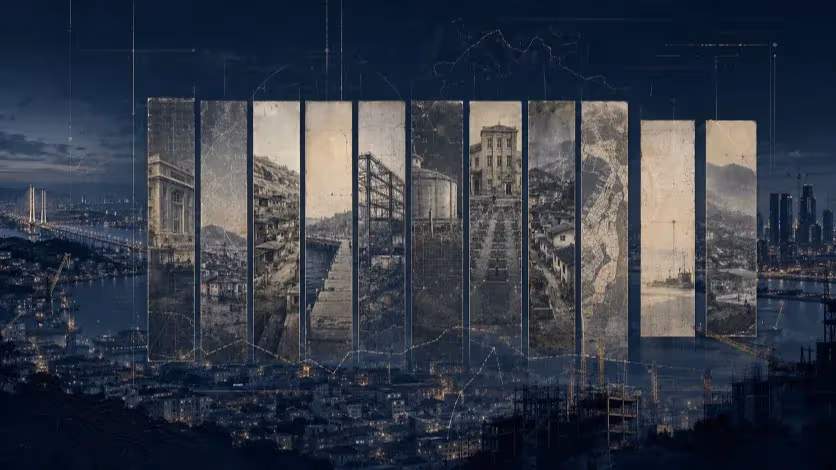
Why Busan’s Nakdonggang River Still Sits Outside the Tourist Route
Busan’s foreign tourism recovery is real, but its geography remains narrow. The Nakdonggang River corridor could widen the city’s visitor map, yet industrial roads, aging factory districts, weak pedestrian links and ecological limits still keep much of West Busan outside the ordinary tourist route.

Foreign visitors are returning to Busan, but the city’s western riverfront remains difficult to enter, follow and spend around — a problem now resurfacing in election promises about West Busan’s future.
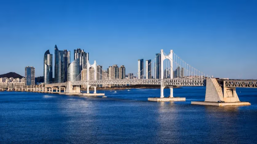
A foreign visitor can use parts of Busan with little instruction. At Gwangalli, the station gives way to the beach, the beach to cafés and restaurants, the bridge to a ready-made line of sight. In the old downtown, BIFF Square and Gukje Market do similar work with denser materials: food stalls, signs, shopfronts, crowds, short crossings. Gamcheon Culture Village turns a hillside into a sequence of viewpoints. These places do not simply receive tourists. They arrange the city for them.
That is the geography behind Busan’s tourism recovery. The city’s first-quarter figures show foreign visitors returning at speed: 1,023,946 arrivals from January to March 2026, the fastest passage beyond one million since Busan began officially announcing foreign visitor numbers in 2014. Foreign tourism spending reached 235.5 billion won, up 26.4 percent from a year earlier. City officials point to cruise tourism, the Visit Busan Pass, mobile payment links and overseas marketing as drivers of the surge. Those explanations help account for how visitors reached Busan. They say less about how much of Busan those visitors reached after arrival.
The available survey data points to a compact city in the tourist imagination. In Busan’s 2024 visitor survey, foreign travelers most often reported visiting Gwangalli Beach, BIFF Square, Gamcheon Culture Village, Gukje Market and Haeundae Beach. The same survey, conducted among 1,060 foreign visitors, showed an average stay of 6.2 days and high satisfaction, but the place names still matter. They describe a Busan that is easy to move through without local knowledge: coast, market, hillside, downtown, beach.
The Nakdonggang River belongs to a different map. It is not absent from Busan. It is too large to be absent. The lower river and its estuary run through the western city as wetland, bird habitat, ecological park, road edge, factory district, port, bridge, reed bed and sunset line. It does not announce itself like Haeundae or Gwangalli. It has to be entered, followed and understood. That demand is part of its value. It is also why the river remains weak in the foreign visitor’s itinerary.
The estuary cannot be treated as vacant waterfront. The lower Nakdonggang migratory bird habitat was designated Natural Monument No. 179 in 1966, with a protected area of 87,279,741 square meters across Busan’s western districts. Busan’s Nakdong Estuary Eco Center describes the estuary as the place where the Nakdonggang River meets the sea, forming a brackish habitat used by migratory birds. Tourism enters this landscape with limits already attached.
The Tourist Map Is a Map of Convenience
Busan’s familiar visitor circuit is often described by its landmarks. That misses how it works. Gwangalli is not only a beach. It is a beach attached to cafés, restaurants, transit, hotels, taxis and a bridge that gives the visitor a clear place to look. Haeundae does the same at a larger scale. BIFF Square and Gukje Market compress food, shopping and movement into a few blocks. Gamcheon Culture Village, despite the pressure tourism places on a residential hillside, gives strangers a visible path through viewpoints and color.
The list of top destinations reads like a map of convenience: beach districts with transit and cafés, old downtown streets with food and markets, a hillside village already organized around viewpoints. These are places where hesitation is reduced. The visitor does not have to decide every step. The district keeps offering the next one.
Food helps explain why these routes hold people. Busan’s English city briefing on the 2024 visitor survey said 46 percentof international travelers chose exploring local food establishments as their most satisfying activity, ahead of traditional culture experiences and natural scenery. The figure does not reduce tourism to dining. It shows how easily food extends a visit. A beach without nearby meals is a view. A market without food is a street. In Busan’s familiar circuit, food keeps the tourist map from ending too quickly.
West Busan has not built the same ease around the Nakdonggang River. Its sites are real enough: Samnak Ecological Park, Eulsukdo Island, Jangnim Port, Amisan Observatory, Dadaepo Beach, Hwamyeong Ecological Park. But they do not yet sit in the visitor’s mind as one usable district. They appear as separated points, each requiring a choice, a transfer, a calculation. A local resident may know how to make an afternoon out of them. A foreign visitor is more likely to see distance.
The difference is not charm. It is sequence. The eastern coast and the old downtown carry visitors from one decision to the next. Along the Nakdonggang River corridor, the sequence is thinner. A park may be large. A port may be photographed. An observatory may explain the estuary. A beach may hold the sunset. The question is what happens between them.
The River Outside the Itinerary
The Nakdonggang River does not enter Busan’s tourism map in the same way a beach does. A beach gives the visitor an edge, a horizon, a place to stand. The river in West Busan is harder to reduce. It widens into an estuary, breaks into deltas and sandbars, holds reed beds and tidal flats, passes ecological parks and factory districts, and reaches the sea through a landscape that is neither fully urban nor fully wild.
That difference is easy to miss if the river is treated as scenery. The lower Nakdonggang is a protected habitat before it is a tourism site. The estuary mixes freshwater and seawater. It supports migratory birds through reeds, tidal flats, aquatic life and the food chain built around brackish water. The protected landscape crosses the same districts that Busan now wants to draw more deeply into its visitor economy.
This makes the river a difficult subject for tourism policy. It cannot be handled as empty waterfront waiting for cafés, promenades and night lighting. Its value lies partly in the parts that resist quick consumption: shallow tidal flats, bird habitats, seasonal reeds, wide distances, restricted zones, places where the view is better understood with a guide than with a camera. A visitor may come for sunset. The river’s meaning sits in a system that does not fit neatly into a short stop.
Samnak Ecological Park shows both sides of the problem. On paper, it is one of Busan’s strongest riverfront assets. The Korea Tourism Organization describes it as the largest of four riverside parks along the Nakdonggang River, covering 4.89 square kilometers and stretching 7 kilometers, with wetlands for migratory birds, bird feeding fields, lawns, wildflower areas, ecological trails, sports facilities and bicycle rental stations. The scale is not in question.
Scale, however, is not the same as approach. A large river park can remain thinly attached to the city around it. It can receive cyclists, runners, festival crowds and residents who already know the route, while still failing to enter the itinerary of a visitor who needs the city to explain itself.
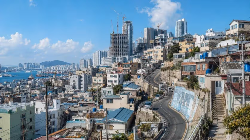
Sasang-gu: The Park That Keeps Needing a Way In
Samnak has never lacked size. What it has repeatedly needed is a way in.
The park sits along the Nakdonggang River as one of Busan’s broadest riverfront open spaces, large enough for cycling, wetlands, sports fields, weekend picnics, seasonal flowers, festivals and running events. It is also the kind of place local governments can easily imagine as a green front for West Busan: a landscape that can soften the image of old industrial districts and give the river a more public face.
The language around Samnak has changed faster than the approach. It can be described as a garden, a park, an event venue or a future flagship riverfront. On the ground, the question has remained stubbornly practical: how does the city cross the roads in front of it?
That question has been returning for years. In 2022, local reporting described the area across from Samnak Ecological Park as cut off by two wide industrial roads, making movement between Samnak-dong and the park difficult. A pedestrian bridge project costing nearly 29 billion won drew questions over location, usefulness and operating costs. A bridge meant to solve access had itself become a debate about where access should begin.
A later report made the problem plainer. It said the park had only one accessible crosswalk and too few pedestrian bridges, with Gangbyeon-daero making the park difficult to reach on foot. The city had moved toward a broader study of access to Nakdonggang River parks, raising concerns that isolated fixes could fail to connect with one another. That explanation is useful because it admits the larger issue: one bridge cannot repair a disconnected edge.
Samnak exposes a basic weakness in West Busan’s tourism geography. The park is already there. The city has repeatedly had to build, propose, revise or delay ways of entering it. Vehicle roads, pedestrian bridges, design reviews, garden events and tourism ambitions all circle the same fact: the riverfront does not meet the surrounding city cleanly.
A place reached mostly by intention — by car, bicycle, event registration or local familiarity — behaves differently from a district that absorbs a visitor from the street. Samnak can fill with runners for a morning and still remain outside the everyday tourist map. It can hold a festival and still fail to carry visitors into nearby streets, meals, markets or industrial history. It can be large enough for a citywide ambition and still ask too much of a stranger stepping out of a station.
The Industrial City Behind the River
The broken approach to Samnak is not an accident of poor wayfinding. It belongs to the older logic of Sasang-gu. This part of West Busan was not arranged first for walking, leisure or visitors. It was arranged for production.
Sasang Industrial Area stretches across Hakjang-dong, Gamjeon-dong, Gwaebeop-dong, Deokpo-dong, Mora-dong, Samnak-dong, Jurye-dong, Eomgung-dong and parts of Gupo-dong. Historical accounts describe the area as a major industrial district shaped by Busan’s need for planned industrial land, with small and medium-sized manufacturers in steel, machinery, rubber, chemicals and textiles concentrated there by the 1970s.
The factories are not an accident beside the river. They are part of the reason the riverfront looks and works the way it does. Roads, warehouses, workshops, logistics yards and industrial supply shops did not appear near the river by mistake. They were the working structure of a manufacturing city.
For tourism, that inherited structure produces a different kind of difficulty from simple distance. Samnak Ecological Park may be close to stations and residential districts on a map, but the route to it passes through a landscape built for vehicles, loading, distribution and workday movement. A visitor moving toward the river does not simply cross space. The visitor crosses an old boundary between the productive city and the recreational city.
This is where a tourism article can easily become too simple. Aging factories are not merely a stain to be removed before visitors arrive. They are part of Sasang’s urban biography. A more careful tourism strategy would have to decide what to keep visible, what to repair, and where the riverfront should meet the working city instead of pretending the working city was never there.
The temptation is to treat the river as an escape from industry: cross the road, leave the factories behind, enter the park. That may produce a cleaner brochure. It misses the shape of the place. Sasang’s riverfront is not nature on one side and industry on the other. It is the seam between them.
Saha-gu: The Estuary Has Pieces of an Itinerary
Saha-gu gives the Nakdonggang River its clearest sequence of images. Eulsukdo Island holds the ecological center and the migratory bird habitat. Jangnim Port offers the small harbor and the colored waterside buildings now sold under the “Bunezia” name. Amisan Observatory looks down on the river as it breaks toward the sea. Dadaepo Beach takes sand deposited by the Nakdonggang River and turns it into a wide public edge, with shallow water, walking paths, water activities and a seasonal fountain. Few districts in Busan contain so many parts of the estuary story in such a short distance.
The difficulty is that these places still behave more like a set of stops than a continuous route. They are close enough to be named together in tourism copy. They are not yet easy enough to move through as one afternoon without planning. A visitor can go to Dadaepo for the beach, to Jangnim for the photograph, to Amisan for the view, to Eulsukdo for the birds or the museum. The harder journey is the one that connects them without a car, without local knowledge and without the feeling that each transfer begins the trip again.
Jangnim Port shows the tension most clearly. Its recent visibility comes from surfaces: colored doors, small boats, narrow water, a bridge across the harbor, a second-floor view over the port, the sunset behind low industrial and residential edges. The port is photogenic. A photograph can make a place visible faster than it can make it connected.
The older geography remains underneath. Jangnim is not a sealed tourist quarter. It sits inside a working district shaped by port use, small industry, warehouses, roads and ordinary neighborhood life. That is part of the place’s value. It is also why the route matters. If the visitor arrives, takes the picture and leaves, the port remains a backdrop. If the visit can continue into food, local shops, the estuary trail, the observatory or the beach, the image begins to carry economic weight.
Amisan Observatory does a different kind of work. It explains the estuary from above. From the hill near Dadaepo, the visitor can look down at the point where the Nakdonggang River and the sea meet. The observatory turns the estuary from scenery into geography. But that interpretive value is fragile if the route around it remains thin. A view from above can clarify the landscape. It cannot connect Jangnim, Eulsukdo and Dadaepo on the ground.
Saha-gu already holds the parts of an estuary route. The route still has to be assembled: Eulsukdo for ecology, Jangnim for the working port and image economy, Amisan for the geography of the estuary, Dadaepo for the public edge where the river finally meets the sea. Without that sequence, the visitor sees scattered places. With it, Saha-gu could give Busan a river route the eastern coast cannot copy.
Buk-gu: A Bridge Is Not a District
Buk-gu offers the clearest counterpoint in the western river corridor. In December 2024, the district opened Gamdong Naru-gil Riverwalk, a pedestrian-only bridge linking Gupo Station to Hwamyeong Ecological Park. The bridge is 320 meters long and three meters wide, built at a cost of 16.8 billion won. Its design refers to the old Gamdongjin ferry crossing, a reminder that this part of the Nakdonggang River once worked as a place of movement and exchange before modern roads and rail fixed the river into a different urban role.
The bridge matters because it solves a small problem with large consequences. It lets a person leave a station and reach the river on foot. That sentence sounds almost too ordinary, but ordinary access is exactly what much of the Nakdonggang River corridor lacks.
That does not make the Gupo–Hwamyeong connection a finished tourism district. A bridge can change the entrance to a place. It cannot decide what happens after the crossing. The test is whether the riverwalk pulls people only into the park, or whether it also sends them back into Gupo’s streets, toward Gupo Market, local food, the old ferry memory and the commercial life around the station.
The distinction is important. West Busan does not need bridges as symbols. It needs crossings that change behavior. If a visitor walks from Gupo Station to Hwamyeong Ecological Park, spends time by the river, returns through the market and eats nearby, the bridge has done more than provide a view. It has extended the district. If the visitor crosses, takes photographs and leaves by the same path, the bridge remains an attractive object over the river, not yet a working piece of tourism infrastructure.
Buk-gu should be treated carefully. It shows what direct access can look like, but it does not prove that access automatically produces a tourism economy. The missing data are the same ones that matter across West Busan: foot traffic after opening, foreign visitor use, changes in nearby sales, evening activity, sign systems, route maps, links to local food and whether the riverwalk connects to programs on the water or remains a stand-alone crossing.
Rail Will Bring People West. It Will Not Finish the Route.
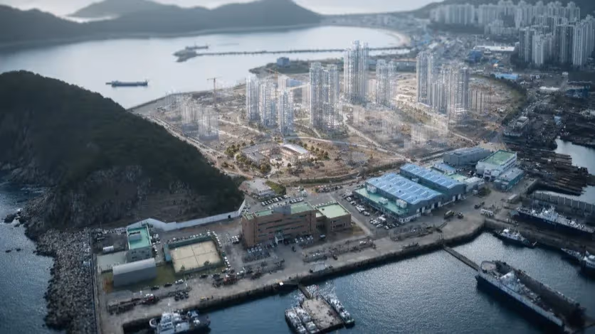
West Busan’s future is often drawn as a rail map. Sasang, Hadan, Eulsukdo, Myeongji, Noksan and eventually Gadeokdo appear as points waiting to be joined. The promise is easy to understand. A stronger rail network would shorten the distance between Busan’s older urban core, its western industrial districts, the Nakdonggang River Estuary and the city’s planned airport gateway.
The projects are real, but they move on a slower clock than the visitor experience. The Sasang–Hadan Line is planned to connect Sasang Station with Hadan Station over 6.9 kilometers; the first phase is now expected around 2027. The line matters because it would bind Sasang and Hadan more tightly. Its delays matter because West Busan’s access problem is not a future abstraction; it is what visitors encounter now.
The next extension carries even more weight. The Hadan–Noksan Line is planned as a 13.47-kilometer route from Hadan Station through Eulsukdo and Myeongji to Noksan, with 11 stations and one depot. In May 2026, the project entered the basic and detailed design stage after procurement and delivery changes. If built, the line would change the daily geography of Gangseo-gu and the western estuary. It would also bring rail closer to places that now rely heavily on buses, cars and local knowledge.
But a tourism route is not built at the scale of a project map alone. Rail can bring a visitor to Hadan, Myeongji or Noksan. It cannot decide whether the visitor understands where to go after leaving the station. It cannot make the walk from a platform to a wetland clear, the crossing over a wide road comfortable, the bus transfer after sunset reliable, the local meal visible, or the ecological limit intelligible. Those are smaller things. They are also the things that decide whether infrastructure becomes tourism or remains transport.
Saha-gu shows the problem in miniature. Hadan Station is already a major interchange point for the western city, and Eulsukdo Island lies close enough to seem nearby on a map. Yet the experience of reaching the estuary still depends on transfers, road crossings, signs and the visitor’s ability to understand where the ecological landscape begins. Future rail may reduce the friction. It will not erase the need to design the ground-level route from station to river.
The same point applies to Sasang-gu. The Sasang–Hadan Line may eventually strengthen the connection between two western districts, but Samnak Ecological Park’s difficulty lies in the approach: the roads, the bridge locations, the industrial edge, the places where walking thins out before the river begins. A rail project can shorten regional distance. It cannot by itself repair that local sequence.
The Election Has Found the River. The Route Has Not.
The local election has brought West Busan back into the language of promise. The words are large: airport, logistics, maritime capital, artificial intelligence, youth jobs, global tourism, western expansion. The Nakdonggang River appears inside that vocabulary as more than a river. It becomes proof that Busan still has land to reorganize, districts to reconnect and a future to sell beyond the eastern coast.
Park Heong-joon has framed Busan’s next stage around Gadeokdo New Airport, a global industrial city and a target of 10 million foreign tourists a year. His campaign language joins air routes, logistics, finance and tourism into one claim: Busan can become a city where companies, talent and visitors arrive and stay. That is a powerful election sentence. It speaks to the same recovery story behind the first-quarter tourism numbers. It does not, by itself, explain what happens after arrival. A foreign visitor can land closer to West Busan and still fail to find a clear way into the riverfront.
Jeon Jae-soo has approached the race from another direction, placing “Maritime Capital Busan,” artificial intelligence and youth employment near the center of his campaign. His argument is less about selling a tourism image than about changing the city’s economic base: ports, marine industries, AI and jobs. That frame has its own relevance to the Nakdonggang River corridor. West Busan’s riverfront is tied to industrial land, logistics, old manufacturing districts and the kinds of work the city wants to keep or replace.
The river also surfaced earlier in the conservative primary through a more direct development language. Joo Jin-woo proposed making the Nakdonggang belt a center of the wider Busan-Ulsan-Gyeongnam economy, with western transport links, water-leisure spaces and advanced industrial clusters on aging industrial land. The proposal was easy to understand politically. It treated the river as the spine of West Busan’s correction: transport, leisure, industry and jobs gathered along one line.
These campaign languages differ, but they share a habit. They make the river large before they make it usable. The airport brings the world closer. The maritime-capital frame restores Busan’s economic identity. The development plan turns the river into a growth axis. Each speaks to a real weakness in the city. West Busan has been underused in the tourist map, separated by roads and industrial land, and too often treated as the backside of metropolitan Busan. Yet the promises move quickly from the river as it is to the river as a future symbol.
The ground-level problem is smaller and more stubborn. Can a visitor leave Sasang Station or Gwaebeop Renecite Station and understand the way into Samnak Ecological Park without treating the trip as a local errand? Can Hadan Station work as a real entrance to Eulsukdo Island, Jangnim Port, Amisan Observatory and Dadaepo Beach, rather than a transfer point for those who already know the area? Can the Gupo–Hwamyeong riverwalk pull movement back into Gupo Market and the streets around the station, instead of ending as a scenic crossing? Can a protected estuary receive more visitors without being turned into another strip of waterfront consumption?
Those questions happen at the scale where tourism is actually decided: a crossing, a sign, a shaded path, a bus after sunset, a meal close enough to extend the visit, a guide who can explain why a wetland is fenced, a market that benefits from the walk rather than watching visitors pass by. Election campaigns prefer larger units. Airports, railways, industrial clusters and tourist targets are easier to announce. They do not settle the last 500 meters.
The campaign has made the Nakdonggang River easier to speak about. It has not made the route easier to walk.
What Would Count as Growth
Busan should be careful about the numbers it chooses to celebrate next. More visitors to the Nakdonggang River corridor would not automatically mean better tourism. A crowded park, a longer traffic line, a seasonal festival or a spike in photographs from one harbor would be easy to count. They would say little about whether the western riverfront has become part of the city visitors can actually use.
The better measures are harder and more local. How many foreign visitors reach Saha-gu, Sasang-gu, Buk-gu and Gangseo-gu after arriving in Busan. How long they stay in those districts. Whether they spend money outside the first attraction. Whether a visit to Eulsukdo leads to Jangnim, Amisan or Dadaepo. Whether a walk across the Gupo riverwalk brings people back into Gupo Market. Whether Samnak’s events leave any trace in nearby streets after the race tents come down.
Those questions would make the tourism debate less comfortable. They would also make it more honest. The city already knows how to count arrivals. It is less clear whether it can count distribution. A visitor who spends one night in Haeundae, photographs Jangnim Port and leaves may appear in the recovery story. A visitor who spends half a day moving through Eulsukdo, eats in Saha-gu, takes the estuary seriously and returns after sunset belongs to a different kind of tourism economy.
The Nakdonggang River corridor will also need limits that Busan’s beach districts do not require in the same way. A protected estuary cannot be evaluated only by visitor volume. Some areas should receive people slowly. Some should receive them seasonally. Some should be seen from observatories, guided routes or controlled paths rather than open access. The city will have to decide where tourism should expand and where it should stop.
That is the hardest distinction for policy to hold. The riverfront needs to become easier to enter, but not easier to consume carelessly. It needs clearer routes without flattening the landscape into a theme park. It needs food, interpretation and transport without turning every quiet edge into a commercial strip. West Busan’s advantage is that it does not look like the eastern coast. Losing that difference would be the quickest way to weaken the argument for sending visitors there.
The work is also social, not only spatial. If the Nakdonggang River becomes a tourism corridor, the benefits cannot stay inside public plans or event budgets. They have to reach the small restaurant after the river walk, the market near the station, the guide who can explain the estuary, the neighborhood that bears the weekend traffic, the worker whose district is being reintroduced to outsiders as scenery. West Busan’s industrial history should not become background texture for visitors while the local economy receives only inconvenience.
A successful Nakdonggang River strategy would make the river easier to reach without making the estuary weaker. It would let visitors move from station to river to neighborhood without guessing at every step. It would connect Saha’s estuary sites, Sasang’s park and industrial edge, Buk-gu’s station-to-river link and Gangseo’s future gateway without pretending they are the same place. It would give West Busan a tourism economy that fits its land, rather than importing the habits of the beach districts.
Busan’s tourism recovery has made the old map more visible. The familiar circuit still works, and it will remain central. But a city receiving more foreign visitors has less room to leave its western riverfront as a set of difficult fragments. The Nakdonggang River does not need to be sold as another spectacle. It needs the more ordinary work of becoming reachable, readable and worth staying near. Only then can the river move from the edge of Busan’s tourism story into the body of it.
Editorial Context
"Independent journalism relies on radical transparency. View our full log of editorial notes, corrections, and project dispatches in the Newsroom Transparency Log."
Reader Pulse
The report's impact signal
Be the first to provide a reading pulse. These collective signals help our newsroom understand the impact of our reporting.
Join the discussion
A more thoughtful conversation, anchored to the story
Atlantic-style discussion for this article. One-level replies, editor prompts, and moderation-first participation are now powered directly by Prisma.
Discussion Status
Open
Please sign in to join the discussion.
The Weekly Breeze
Independent reporting and analysis on Busan,
Korea, and the broader regional economy.