What the Oceans Ministry’s Move Reveals About Sujeong-dong
The temporary headquarters sit between the station corridor and a hillside district marked by steep terrain, aging housing and long-standing redevelopment constraints.


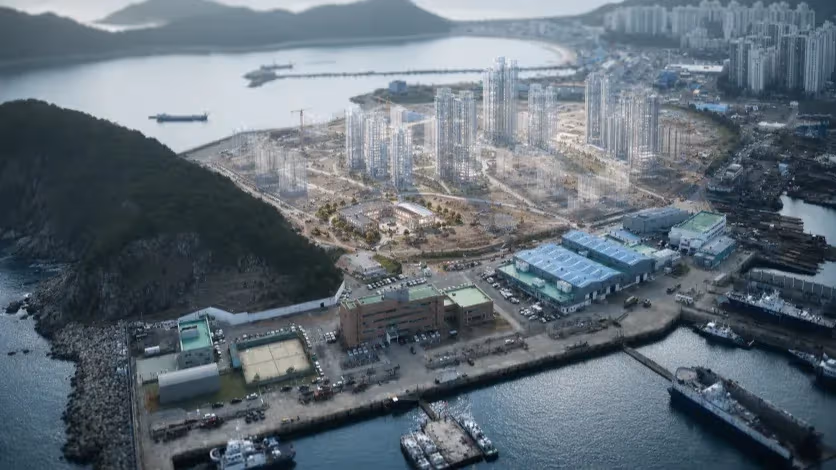
Busan, South Korea — The Ministry of Oceans and Fisheries began relocating staff from Government Complex Sejong to Busan in December, moving its operations into two commercial office towers in Sujeong-dong—IM Building as the main office and Hyupsung Tower as an annex. Both structures are existing private buildings situated along a short corridor between Busan Station and the lower foothills of Dong-gu. They function as temporary headquarters rather than a purpose-built complex, as the government has not yet designated a permanent site for the ministry in Busan. Approximately 800 employees are scheduled to complete the move by late December, with their residential accommodations spread across districts such as Busanjin-gu, where the city secured about 100 units of newly built housing for ministry staff.
The immediate surroundings of the new offices consist of mid-rise, mixed-use buildings constructed between the 1970s and early 2000s, many of them positioned along Choryang-ro and the primary station access roads. These streets already support a concentration of small restaurants, logistics offices, travel agencies, and long-standing retail shops that serve commuters and port workers. Several ground-floor units that had remained vacant in previous years were newly leased ahead of the relocation, though no comprehensive commercial impact assessment has been released. The road network in this area is relatively flat and directly connected to Busan Station, the port access corridor, and major bus lines.
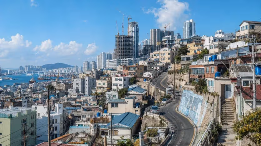
A short distance east of the ministry buildings, the urban form shifts abruptly. The base of the hillside marks the beginning of Sujeong-dong’s older residential area, where elevation rises sharply within the span of a few blocks. Roads decrease in width until they give way to stepped pedestrian paths. Many of the homes positioned along these slopes were built during the 1950s and 1960s, when rapid postwar urban growth pushed low-income households onto steep land not serviced by modern infrastructure. The buildings are predominantly two- to three-story structures with accumulated incremental repairs, varied extensions, and non-standardized construction methods common to that period.
Public records from Dong-gu identify persistent structural issues within these hillside clusters: a high proportion of deteriorated housing units, limited fire-truck access due to substandard road width, and continuing population decline. The area has one of the highest concentrations of elderly residents in Busan, with several census blocks showing senior population ratios exceeding one-third. While the city has installed small-capacity slope elevators and renovated certain stairways, the majority of the housing stock and circulation routes remain largely unchanged from earlier decades.
The ministry’s temporary headquarters therefore occupies a transitional zone between two distinct urban environments: the transit-oriented station district, which retains relatively stable commercial activity, and the hillside neighborhoods where structural constraints—slope, road width, aging housing, and demographic imbalance—limit the feasibility of conventional redevelopment. The relocation does not alter these conditions but situates a central administrative body within them, creating a rare case in which a national ministry begins its operations not in a newly built complex or an emerging district, but at the boundary of a declining inner-city hillside settlement.
Sujeong-dong’s Terrain and Population
Sujeong-dong occupies the hillside that rises immediately east of Busan Station, forming part of Dong-gu’s dense inner-district topography. The transition from the flat station corridor to the slope occurs within a few blocks. The lower area, where the ministry’s temporary offices are located, consists of mid-rise commercial and officetel structures built along arterial roads connected to the station and port access routes. Above this corridor, the ground elevation increases rapidly, and the urban form shifts into compact residential clusters arranged along narrow routes that follow the slope.
The hillside area reflects construction patterns common during the 1950s through the 1970s, when Busan’s population expanded rapidly and housing demand outpaced planned land development. Many structures in Sujeong-dong were built incrementally on small parcels carved out of the hillside. Road widths in these upper sections frequently fall below the four-meter standard required for fire-truck access, and several segments can only be reached via stepped pedestrian paths. Housing units in these clusters typically consist of two- or three-story buildings with mixed materials, multiple layers of repairs, and irregular extensions added over decades without coordinated redevelopment.
Public records from Dong-gu classify a substantial portion of Sujeong-dong’s housing stock as old or deteriorated. Safety assessments identify recurring issues involving aging retaining walls, drainage limitations on steep terrain, and vulnerability during heavy rainfall. The district has participated in municipal improvement programs—such as slope elevator installations, stairway reinforcement and minor open-space projects—but these interventions have not altered the underlying structural composition of the residential area.
Demographically, Sujeong-dong follows the broader trajectory of Dong-gu, which has experienced continuous population decline for more than two decades. The district’s aging ratio ranks among the highest in Busan. Census data show that elderly residents constitute over one-third of the population in several hillside blocks, with younger households disproportionately relocating to outer districts where large apartment complexes are more common. The imbalance contributes to a declining labor force, reduced household turnover and limited potential for market-driven redevelopment.
Sujeong-dong’s physical and demographic conditions form a coherent pattern characteristic of Busan’s older hillside districts: steep terrain limiting vehicular access, fragmented land parcels constraining redevelopment, a high proportion of elderly residents, and a predominance of small, aging structures. The area’s urban form and population structure have proven resistant to change despite multiple rounds of municipal improvement projects, creating a setting in which long-standing constraints remain intact as the ministry begins operations in the lower part of the neighborhood.
Why Past Regeneration Efforts Stalled on the Slopes
Regeneration initiatives in Busan’s hillside districts began more than a decade ago as part of a municipal program directed at improving conditions in areas built during periods of rapid population growth. Sujeong-dong and adjacent neighborhoods formed a significant part of these efforts due to their steep terrain, aging housing stock and high concentration of elderly residents. Projects introduced in these areas followed a similar pattern: repair of stairways, installation of slope elevators, construction of small public spaces and reinforcement of pedestrian networks linking homes on the hillside.
These interventions addressed visible deterioration but left underlying structural conditions unchanged. The residential clusters consist of parcels subdivided at irregular angles along steep gradients, with most lots too small for standard redevelopment and many roads below the width required for emergency vehicle access. Parcel fragmentation prevents consolidation into development blocks that could support financially viable rebuilding, and the topography limits the use of conventional apartment construction methods common in Busan’s newer districts. As a result, redevelopment has remained technically and economically difficult.
The demographic structure of the hillside areas further constrained the impact of regeneration programs. A large share of households consist of elderly residents with limited financial capacity to participate in redevelopment or relocation. Younger households have continued to move to districts where modern apartments and flat land offer more convenient access and larger unit sizes. The imbalance between aging residents and departing younger families has resulted in reduced demand for local services and declining housing turnover, limiting the scale of market-driven improvement.
Regeneration projects often relied on short-term funding cycles, producing isolated upgrades rather than comprehensive restructuring of the neighborhood. Physical improvements such as retaining wall repairs, façade treatments and community facilities reduced immediate deterioration but did not alter the basic housing typology or land configuration. The projects also did not include large-scale acquisition of land or relocation support that would allow systematic reorganization of the built environment. Without such structural measures, incremental improvement had limited influence on long-term population trends or housing conditions.
These constraints—steep terrain, fragmented parcels, limited redevelopment feasibility, an aging population and insufficient structural intervention—define the limits of past regeneration efforts in Sujeong-dong and comparable hillside districts. The underlying urban form has remained largely intact, and the neighborhoods continue to experience population decline and deterioration despite multiple rounds of municipal projects. In this context, the ministry’s relocation occurs within an area shaped by long-standing structural barriers that previous initiatives were unable to resolve.
Constraints of Moving Into an Existing City Core
Administrative relocations in South Korea typically involve the development of new complexes on large sites prepared in advance of occupation. The model used for Government Complex Sejong represents this approach: assembled land parcels, wide access roads, standardized block layouts and purpose-built office buildings integrated with new housing districts. These components enable agencies to relocate into environments designed to accommodate large workforces, vehicular access, public transit links and staff residential needs.
The conditions in Sujeong-dong differ markedly from this pattern. The Ministry of Oceans and Fisheries occupies two existing private office buildings situated in a built-out district with no available site large enough for immediate construction of a new complex. The ministry’s facilities are designated as temporary headquarters, and no permanent site has been finalized. The surrounding urban form consists of mid-rise structures positioned along streets laid out decades earlier, with limited space for expansion and no integrated administrative campus.
Housing arrangements for ministry staff also follow a different structure from new-town relocations. Rather than relocating into a newly planned residential district adjacent to the workplace, employees are distributed across multiple parts of Busan, including units secured by the city in Busanjin-gu. Daily movement therefore depends on existing transit infrastructure rather than a purpose-developed residential network tied directly to the administrative complex.
Urban conditions around the ministry’s temporary headquarters present additional contrasts with new-town environments. The lower area near Busan Station contains dense commercial activity and older mixed-use buildings arranged along narrow blocks. A short distance away, the hillside districts contain aging housing and limited vehicular access, with no comprehensive redevelopment underway. These conditions create a setting in which a central administrative body operates within established urban constraints rather than a planned environment designed for institutional relocation.
The relocation therefore situates the ministry within a district characterized by physical and demographic conditions that differ substantially from the standardized environments typical of new-town administrative moves. The absence of planned expansion space, the reliance on existing office structures, and the surrounding mix of commercial corridors and hillside residential areas illustrate a relocation framework shaped by preexisting urban conditions rather than new development. This distinction frames the context in which subsequent considerations of Sujeong-dong’s future redevelopment must be evaluated.
What a Busan-style Regeneration Model Could Look Like
The physical structure of Sujeong-dong limits the applicability of redevelopment models commonly used in Busan’s outer districts. High-rise apartment construction requires large, contiguous parcels and road access capable of supporting heavy equipment and emergency vehicles. The hillside districts consist instead of small, irregularly shaped lots distributed along steep gradients, making land assembly costly and technically complex. Parcel boundaries reflect incremental settlement patterns rather than planned subdivisions, and the topography restricts the creation of uniform development blocks. These constraints reduce the feasibility of private high-density redevelopment and have contributed to the slow pace of structural renewal.
A viable regeneration approach for Sujeong-dong therefore requires a model that aligns with the district’s terrain and existing land patterns. One option involves reorganizing small parcels into terraced, low- to mid-rise housing clusters designed to sit along the slope. This structure can accommodate modern building standards while maintaining forms compatible with the hillside. Such an approach also allows for staggered construction phases, reducing the scale of displacement among long-term residents. Public agencies would need to coordinate land readjustment, acquire key parcels and manage phased reconstruction to create continuous building platforms on terrain that does not support standard block formation.
The district’s demographic profile further indicates the need for a mixed housing program rather than a single market-driven typology. A significant share of elderly residents occupy structures that are difficult to maintain and access, while younger households have limited incentive to move into the area due to the absence of modern units and the lack of parking and flat walking routes. A regeneration model combining senior-oriented housing, public rental units, and limited market-rate units could address both population stabilization and diversification. This mix would allow new households to enter the area without displacing existing residents who rely on low-cost housing.
Integration with the lower commercial corridor near Busan Station is also central to any long-term model. The hillside districts function separately from the flat, transit-oriented zone at the base due to differences in accessibility and building form. Improved pedestrian connections and slope-oriented mobility systems—such as a fixed-route incline transport system—could reduce physical separation. Linking residential areas more directly with the station corridor would provide residents access to jobs, services and transit, while distributing foot traffic beyond the narrow band around the ministry’s temporary offices.
Public-sector leadership is essential for this type of regeneration. Fragmented land ownership and low redevelopment profitability limit private-sector participation, and the terrain requires coordinated interventions that individual property owners cannot undertake. A structured plan would include parcel consolidation, infrastructure renewal, supportive housing programs and targeted infill development. The objective would be to rebuild the hillside districts in a manner compatible with their topography while establishing a stable residential base connected to the broader urban network.
A Busan-style model for hillside regeneration would therefore differ from standardized redevelopment practices. It would rely on terraced building forms, coordinated land management, a mixed-income housing framework and integrated mobility systems, reflecting the physical and demographic realities of districts like Sujeong-dong. The ministry’s relocation provides an administrative presence at the edge of this terrain, but the long-term viability of the area depends on the adoption of a regeneration approach aligned with its structural characteristics.
Building a Sustainable Framework for the Hillside Districts
A long-term redevelopment framework for hillside districts such as Sujeong-dong requires structural intervention at the level of land organization, circulation systems and housing form. The existing pattern of small parcels arranged along steep inclines prevents coordinated rebuilding and limits the introduction of modern infrastructure. To address this, a public-led land readjustment program would need to restructure fragmented ownership into consolidated building platforms. This process involves identifying clusters of lots suitable for reconfiguration, acquiring key parcels that hinder continuity and forming terraces that can support low- to mid-rise construction compatible with the slope.
Circulation networks constitute a second foundational layer. The current system of narrow alleys and stairways restricts mobility for residents and complicates emergency access. A sustainable framework would designate primary access routes along which structural upgrades can be implemented, including roadway widening where feasible, reinforcement of retaining structures and installation of standardized pathways connecting residential clusters to the station-area corridor. Where road expansion is not possible due to terrain, fixed-route slope transport systems could provide continuous uphill movement. Unlike small-capacity elevators that serve short segments, a linear incline system would establish a predictable, high-usage mobility spine linking the hillside to the transit hub at Busan Station.
Housing programs form the third component. The district's demographic structure—characterized by a large share of elderly residents and limited inflow of younger households—requires an approach that balances replacement of unsafe structures with the preservation of affordability. A unified plan would zone the reorganized terraces for varied housing types, including senior-supportive units close to upgraded access routes, small public rental units aimed at stabilizing population levels and market-rate homes positioned to attract younger residents. This mix ensures that regeneration does not replicate the displacement patterns seen in market-driven redevelopment while still introducing a resident base capable of sustaining local services.
Infrastructure modernization provides the fourth layer. Existing drainage systems, retaining walls and utility corridors reflect incremental additions rather than coordinated design. Comprehensive upgrades would require excavation along the newly formed terraces, installation of standardized utility conduits and reinforcement of slope stabilization structures. These improvements reduce long-term maintenance burdens and support housing reconstruction that meets current building standards.
A district-level management structure is necessary to coordinate these components. The structure would oversee land consolidation, manage phased relocation during construction, administer housing support programs and integrate mobility and infrastructure improvements. This coordination is particularly important in hillside districts where terrain restricts the scale and sequencing of construction activities.
Integration with the lower urban corridor completes the framework. The station-area zone already functions as a hub for employment, transit and services. Establishing direct, reliable connections between the hillside terraces and this corridor allows residents to access broader city functions without reliance on private vehicles. This linkage also broadens the potential resident base for hillside housing by reducing the functional separation that currently limits demand.
A sustainable redevelopment framework for hillside districts therefore depends on coordinated land reorganization, slope-compatible mobility, mixed housing programs and infrastructure modernization. These components address structural constraints that incremental upgrades have not resolved, and they position hillside neighborhoods to function as stable residential areas linked to the wider city. The ministry’s presence at the base of the district underscores the importance of establishing such a framework for long-term viability.
What the Ministry’s Move Reveals About Busan’s Old Urban Core
The Ministry of Oceans and Fisheries now operates at the point where Busan’s primary transport hub meets a hillside district shaped by mid-20th-century construction patterns, irregular parcel formation and a concentrated elderly population. The ministry’s move into existing commercial buildings illustrates a relocation structure dependent on the city’s current urban form rather than on the preparation of a new administrative complex. This arrangement places a national institution alongside an area where redevelopment has remained limited due to terrain, fragmented land ownership and long-standing demographic imbalance.
The conditions in Sujeong-dong demonstrate the limitations of applying flat-land redevelopment models to hillside districts. Efforts to improve the area over the last decade addressed individual components of deterioration but did not alter the underlying structure of the neighborhood. The relocation brings continued administrative activity to the base of the hill, while the upper residential clusters retain the physical and demographic characteristics that have defined them for decades.
A long-term approach suited to hillside districts requires reorganization of fragmented parcels, construction methods compatible with steep terrain, integrated mobility between the hill and the station corridor and housing programs that stabilize population levels without relying on large-scale private redevelopment. These elements form the basis of a model that reflects the constraints and capacities of Busan’s older urban core.
Sujeong-dong’s current form limits the impact of incremental improvements, and its proximity to the station corridor provides opportunities only when the two areas are linked through structural planning. The ministry’s presence does not resolve these conditions, but it highlights the need for a redevelopment framework that aligns with the physical and demographic structure of the hillside. Such a framework establishes the conditions under which the district can function as a stable residential area within Busan’s wider urban system.
Editorial Context
"Independent journalism relies on radical transparency. View our full log of editorial notes, corrections, and project dispatches in the Newsroom Transparency Log."
Reader Pulse
The report's impact signal
Be the first to provide a reading pulse. These collective signals help our newsroom understand the impact of our reporting.
Join the discussion
A more thoughtful conversation, anchored to the story
Atlantic-style discussion for this article. One-level replies, editor prompts, and moderation-first participation are now powered directly by Prisma.
Discussion Status
Open
Please sign in to join the discussion.
The Weekly Breeze
Independent reporting and analysis on Busan,
Korea, and the broader regional economy.