How High-Rise Redevelopment Changed Busan’s Streets
Transit access improved along Busan’s main corridors, but adjacent redevelopment failed to translate those gains into stronger street-level conditions.


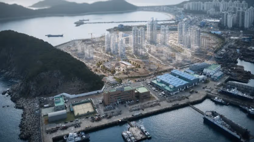
Busan, South Korea — Redevelopment has become the fastest way to remake aging neighborhoods in Busan. Along the city’s major boulevards, low-rise housing and roadside commercial strips have been replaced by high-rise apartment complexes, delivering new housing at a pace unmatched in recent decades. Zoning changes and higher floor-area ratios made these projects financially viable, allowing private developers to consolidate land and build upward where redevelopment could proceed most efficiently.
The result, at first glance, looks like improvement. Streets are cleaner, buildings are new, and population density has increased along corridors that already carried much of the city’s daily movement. But on the same roads, indicators tied to street performance have moved in a different direction. Ground-floor activity has thinned, retail vacancy remains high in newly built complexes, and pedestrian use has shifted toward movement rather than presence.
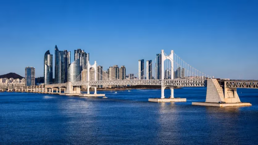
Nowhere is this tension clearer than along Busan’s two central development spines. On Jungang-daero, bus rapid transit has shortened travel times and improved access across the inner city. On Gaya-daero, which extends west from Seomyeon toward Jurye and Sasang, roadside redevelopment has produced long stretches of high-rise housing with limited street-level engagement. In both cases, housing density has risen faster than the streets’ capacity to absorb it as everyday urban space.
This raises a question that cuts beyond individual projects. How did the city’s most accessible roads—those best served by transit and most visible in daily life—become places where walking is increasingly about passing through rather than staying? The answer lies not in the volume of construction alone, but in the development formula applied to these corridors and the street-level conditions it produced.
Why Redevelopment Gravitate Toward Boulevards
“Redevelopment followed the places where density could be approved, financed and built with the least resistance.”
Redevelopment has not spread evenly across Busan’s aging residential areas. Instead, it has followed a narrow set of conditions that make projects financially viable within the city’s regulatory framework. Those conditions are most consistently found along major boulevards.
In commercial and quasi-residential zones, zoning rules allow significantly higher floor-area ratios than in interior residential blocks. Along roads such as Jungang-daero and Gaya-daero, this regulatory capacity combines with parcel size and access conditions that make large-scale land assembly feasible. For private developers, these sites offer a rare alignment of legal density, construction efficiency and market visibility.
Interior neighborhoods operate under different constraints. Parcels are smaller and more fragmented, slopes are steeper, and zoning limits restrict the scale of redevelopment. Even where buildings are physically obsolete, assembling land and financing high-rise construction is far more difficult. As a result, renewal in these areas tends to proceed slowly, if at all, through small-scale replacement rather than comprehensive redevelopment.
The outcome is a form of selective renewal. Aging housing stock remains embedded within interior blocks, while redevelopment pressure concentrates on the edges—along roads that already function as transit corridors, commercial strips and service routes. In Busan, where flat land is limited by surrounding mountains, these edges carry a disproportionate share of redevelopment demand.
Policy incentives have reinforced this pattern. Upzoning and density bonuses, often tied to public contributions such as road improvements or open space, have made boulevard-facing sites the most predictable path to project approval and profitability. Over time, this has established a de facto formula for neighborhood renewal: consolidate roadside parcels, increase allowable density, and build vertically.
That formula explains why new housing has accumulated where it has. It also sets the conditions for the conflicts that emerge at street level, as residential towers are layered directly onto corridors that were already expected to absorb traffic, commerce and pedestrian activity.
When Housing Density Became a Wall
“In a city bounded by mountains, continuous high-rise housing turned major roads into enclosed corridors.”
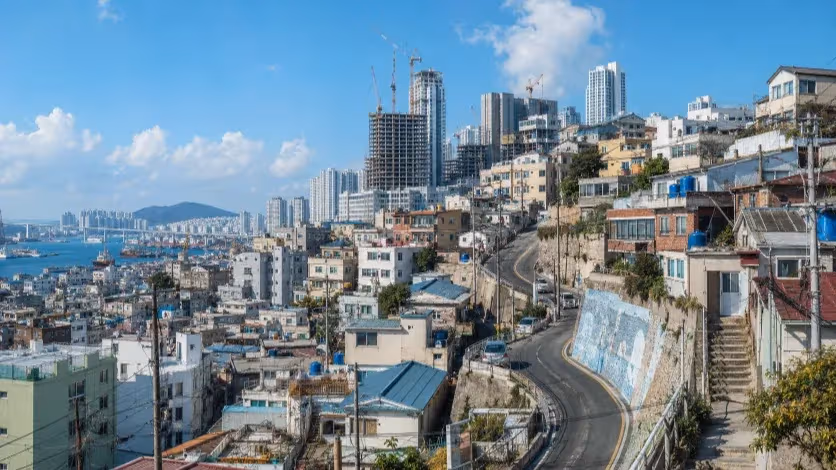
As redevelopment concentrated along Jungang-daero and Gaya-daero, the physical profile of the street changed in ways that go beyond height alone. What emerged was not a series of isolated towers, but long, continuous stretches of residential frontage rising directly from road edges that had not expanded in proportion.
Along both corridors, high-rise apartment complexes now define the street for hundreds of meters at a time. Setbacks are minimal, and variations in building height and façade are limited. Measured against the width of the roadway, these buildings frequently exceed proportions associated in urban design research with pedestrian comfort. The effect is cumulative: enclosure increases not because any single structure is extreme, but because the street is framed by repeated vertical edges without interruption.
In Busan, this enclosure is intensified by terrain. The city’s inner districts sit within a narrow plain bounded by mountain ridges, including Baekyangsan, Eomgwangsan and Hwangnyeongsan. These slopes historically provided distant visual reference points along major roads, helping to offset the scale of traffic infrastructure. As redevelopment progressed, roadside towers progressively blocked those sightlines, compressing the visual field available to pedestrians and transit users alike.
The geometry of the street shifted accordingly. Sky visibility narrowed, long views were replaced by near-field surfaces, and the sense of spatial depth diminished. International studies on street canyons link these conditions to reduced airflow, higher thermal stress and shorter pedestrian dwell times. Along redeveloped segments of Jungang-daero and Gaya-daero, the built form now aligns closely with those conditions.
At pedestrian height, repetition reinforces the effect. Residential façades present similar rhythms—lobbies, security desks, landscaped buffers and vehicle access points—repeated across multiple projects. Entrances are spaced farther apart than in pre-redevelopment streetscapes, and the ground plane offers fewer cues that invite stopping or crossing. The street remains navigable, but it becomes visually and spatial monotonous.
What distinguishes this transformation is its scale and continuity. The issue is not the presence of tall buildings in a dense city, but the way they line the road without interruption, in a landscape already constrained by topography. In such settings, form becomes function. The physical enclosure created by continuous high-rise housing sets the conditions under which the street operates, long before questions of retail or pedestrian programming arise.
What Changed at Street Level
“Walking did not disappear, but the street stopped giving people reasons to stay.”
The shift in built form along Jungang-daero and Gaya-daero was accompanied by a quieter change at ground level. While sidewalks remain continuous and pedestrian movement has not disappeared, the way these streets function for daily use has altered in measurable ways.
One change is the loss of permeability. Redevelopment projects typically consolidate multiple parcels into a single site, replacing fine-grained street networks with large blocks. Public pedestrian passages and open spaces are often included as part of project approvals, but their practical contribution varies. Field observations show that some routes are indirect, visually unclear, or partially restricted by access controls, reducing their usefulness as everyday throughways. The street becomes easier to move along than to move across or through.
Ground-floor composition has shifted as well. In newly built residential complexes, street-facing space is dominated by lobbies, security desks, landscaped buffers and vehicle entrances. Active frontage—shops, services, or frequently used entrances—occupies a smaller share of the block length than in pre-redevelopment conditions. Where retail space exists, it is often divided into small, individually owned units, limiting coordinated management and tenant stability.
Commercial data reflects the consequences. Retail spaces within new apartment developments along these corridors show persistently high vacancy rates, even as residential density increases. In several locations, existing neighborhood shops closed during redevelopment, while replacement retail struggled to establish long-term occupancy. Studies on commercial performance consistently point to ownership fragmentation and the absence of unified management as factors associated with shorter business lifespans and repeated vacancy.
Pedestrian behavior has adjusted accordingly. With fewer destinations and less variation at eye level, walking becomes more directional and less exploratory. The street supports movement—particularly between transit stops—but offers fewer reasons to pause, browse or linger. This distinction matters along corridors served by high-capacity transit, where pedestrian presence is frequent but increasingly transient.
The combination of reduced permeability, inactive frontage and unstable retail creates a self-reinforcing cycle. Limited street-level activity discourages foot traffic beyond peak commuting hours, which in turn weakens commercial viability. Over time, the ground floor functions less as part of the public realm and more as an extension of private residential space.
These outcomes are not the result of a single project or design decision. They appear repeatedly along redeveloped segments of both Jungang-daero and Gaya-daero, suggesting that they stem from the redevelopment model itself rather than from isolated execution failures.
Renewal Without Street Performance
“Busan delivered housing faster than it rebuilt the everyday life of its streets.”
Redevelopment has reshaped large parts of central Busan with speed and consistency. Along Jungang-daero and Gaya-daero, aging buildings were replaced, housing density increased, and transit access improved. By conventional measures of renewal, the transformation appears successful.
Yet the streets that absorbed this change now operate differently. Density accumulated along narrow corridors rather than dispersing across neighborhoods. Continuous high-rise housing altered the physical enclosure of the street, particularly in a city where mountains already limit spatial openness. At ground level, parcel consolidation and residential-first design reduced permeability, weakened active frontage and left commercial space struggling to sustain long-term use.
These outcomes did not arise from a single design flaw or isolated project. They recur across multiple redeveloped segments, shaped by the same regulatory incentives, construction logic and site conditions. The result is a form of renewal that improves buildings faster than it improves streets.
What emerges from Busan’s recent redevelopment cycle is a gap between housing delivery and street performance. Transit corridors became denser, but not necessarily more urban in the everyday sense. The city’s most accessible roads now carry more residents and more movement, while offering fewer reasons to remain.
Editorial Context
"Independent journalism relies on radical transparency. View our full log of editorial notes, corrections, and project dispatches in the Newsroom Transparency Log."
Reader Pulse
The report's impact signal
Be the first to provide a reading pulse. These collective signals help our newsroom understand the impact of our reporting.
Join the discussion
A more thoughtful conversation, anchored to the story
Atlantic-style discussion for this article. One-level replies, editor prompts, and moderation-first participation are now powered directly by Prisma.
Discussion Status
Open
Please sign in to join the discussion.
The Weekly Breeze
Independent reporting and analysis on Busan,
Korea, and the broader regional economy.