How Busan Built Its Waterfront Identity Around Seven Bridges
The city’s 52-kilometer coastal belt connects seven bridges from Gadeok to Haeundae. The view is unified, but toll roads, freight traffic and limited walkways still shape how residents move along the shoreline.


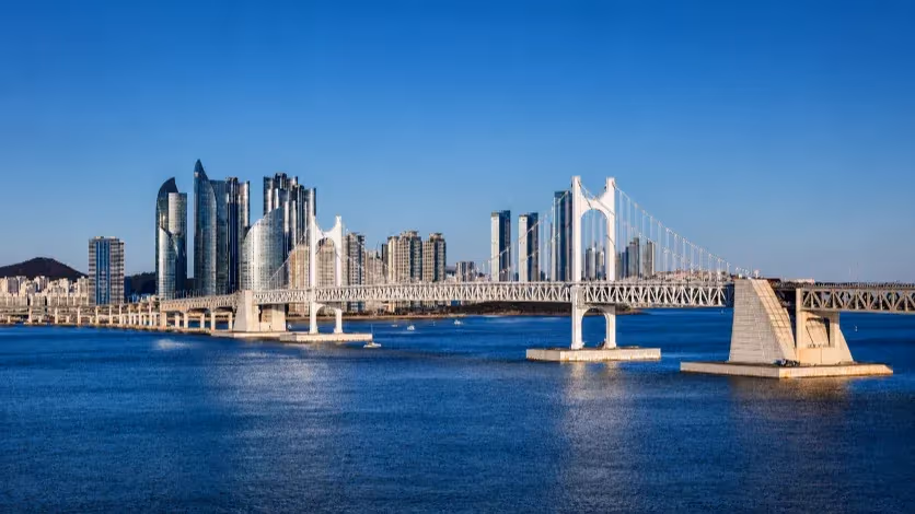
Busan, South Korea — On a clear night in Gwangalli, Gwangandaegyo Bridge stands out more than it did a month ago. The new LEDs sit closer together along the cables, and the moving light units run in a steadier line. The water below catches the colors first, then reflects them toward the beach, giving the bridge a sharper outline than it has had at any point in the past decade. Busan completed the upgrade this fall, replacing more than 13,000 fixtures, a scale that makes the project one of the largest lighting renewals attempted on a coastal bridge in Korea. The city frames the work as part of the Seven Bridges initiative, a 52-kilometer waterfront chain that supports both daily movement and the city’s promotional identity. The view has changed; the way people move along the coast has not.
Gwangandaegyo has shaped the city’s image since its opening in 2003. It created a direct connection between Gwangalli and Haeundae at a time when the east–west movement relied on inland detours, and the bridge’s curve across the bay provided the backdrop for Busan’s shift toward a more tourism-oriented waterfront. The new lighting is the first major update since 2013, and the technical changes show up clearly: tighter spacing along the superstructure, more consistent movement across the cables and better coordination with the shoreline’s ambient light. From the viewpoint of local residents, the renewal restores the bridge to its role as the centerpiece of the city’s nighttime skyline.
The bridge marks the eastern end of the broader coastal belt. Busan officially designates seven bridges along this line—Gadeokdaegyo, Shinhodaegyo, Eulsukdodaegyo, Namhangdaegyo, Yeongdodaegyo, Busanhangdaegyo and Gwangandaegyo. The list is used in tourism, branding and event coordination, but the structures differ sharply in scale and function. Yeongdodaegyo, a short bascule bridge linking Jung-gu and Yeongdo, serves mainly pedestrian and local travel and does not support the through-movement that defines the rest of the chain. The functional east–west corridor instead runs through Gadeokdaegyo, Shinhodaegyo, Eulsukdodaegyo, Namhangdaegyo, Busanhangdaegyo and finally Gwangandaegyo. This is the route a driver takes when traveling from the New Port area to the beaches, and it anchors the city’s coastal mobility.
Each segment carries a different share of the city’s activity. Gadeokdaegyo and Shinhodaegyo are dominated by port traffic, reflecting the role of the New Port and the Noksan Industrial Complex as anchors of Busan’s logistics economy. Around these bridges, the roads feed directly into freight corridors rather than residential areas, and the effect is visible throughout the day: steady truck volume, limited pedestrian presence and a transport landscape shaped by long-haul movement. Eulsukdodaegyo links the west side of the city to the inner districts, offering a more balanced mix of commuters, buses and local trips. The surrounding estuary remains one of the city’s most protected ecological areas, and the bridge’s design—curved alignment, low visual intrusion—reflects this constraint.
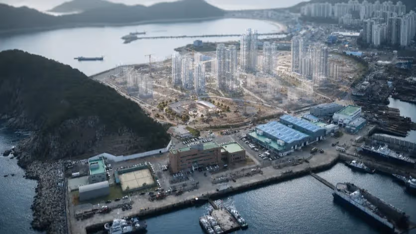
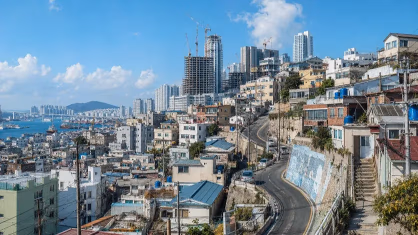
Closer to the old downtown, Namhangdaegyo and Busanhangdaegyo absorb the split between residential and industrial activity. Namhangdaegyo connects neighborhoods along the older coastline, where pedestrian paths, hillside housing and small commercial blocks coexist with port operations. Busanhangdaegyo, a straight cable-stayed span, delivers traffic into the redeveloping North Port, where large-scale construction and new public spaces are gradually replacing older port structures. Together, the two bridges form the hinge between the city’s legacy waterfront and its newer, more commercially oriented districts. Gwangandaegyo completes the chain to the east, feeding into Centum City, Haeundae and the dense strip of beaches and apartment towers that have come to define Busan’s outward-facing image.
Seen from above, the coastline looks unified; from ground level it breaks into a sequence of entirely different environments. The western end is shaped by freight and industrial land use. The midsection blends port activity with older residential areas. The eastern section revolves around tourism, high-rise living and festival spaces. The Seven Bridges narrative compresses these differences into a single storyline, but the conditions that shape daily life along the waterfront depend on which district a person lives or works in.
Mobility patterns reflect this divide. Several sections of the east–west corridor remain toll roads, and drivers commuting between the western districts and the city center often pay multiple charges in a single trip. The toll points are tied to historical financing structures—some sections were built under different authorities and funding models—and the effect is visible during peak hours. Commuters alter routes not because of distance but because of cost. Freight operators face less flexibility, and their trucks continue to dominate the western spans during morning and evening peaks.
Pedestrian access is similarly uneven. Yeongdodaegyo remains one of the few bridges where walking is not only possible but common, especially near the markets and older streets of Nampo. Namhangdaegyo includes a walkway, though its proximity to the port and its lack of strong destinations reduce its use. Shinhodaegyo has sidewalks in both directions, but the industrial landscape surrounding it limits foot traffic. Gwangandaegyo and Busanhangdaegyo remain closed to pedestrians, removing the possibility of a continuous coastal walking experience. This pattern leaves large sections of the coastline accessible only by car, despite forming part of the city’s primary promotional materials.
Traffic congestion adds another layer. The freight-heavy west struggles with predictable bottlenecks, while the east faces tourist-driven slowdowns around Centum City and the beaches. The coastal belt shortens travel times in theory, but the feeder roads around each bridge dictate how well the system functions. A narrow ramp, an uncontrolled intersection or a mixed-use road carrying both trucks and buses can reduce the benefit of the bridges themselves. These friction points are more decisive than the bridges’ physical forms.
Policy changes have unfolded slowly. The city has introduced limited rush-hour toll exemptions on certain segments and continues to discuss new tunnels and arterial adjustments. Some of these proposals aim to separate freight from residential corridors, a long-standing issue that shapes the experience of districts along the western coast. Other proposals focus on improving the access points around major commercial hubs. For now, the overall structure remains the same: cars dominate long-distance coastal travel, pedestrian options remain narrow and the differences between districts persist.
The coastline is physically complete, but the question of how evenly it serves residents remains open. Gwangandaegyo’s renewed lighting sharpens the skyline, and the Seven Bridges narrative offers a clear frame for the city’s waterfront identity. The daily experience of moving along that same coastline reflects a different pattern: toll gates, freight routes, limited walkways, inconsistent access and districts whose needs and conditions do not align. The bridges outline Busan’s coastal form with precision; the movement across them shows how layered—and how uneven—the connection still is.
Editorial Context
"Independent journalism relies on radical transparency. View our full log of editorial notes, corrections, and project dispatches in the Newsroom Transparency Log."
Reader Pulse
The report's impact signal
Be the first to provide a reading pulse. These collective signals help our newsroom understand the impact of our reporting.
Join the discussion
A more thoughtful conversation, anchored to the story
Atlantic-style discussion for this article. One-level replies, editor prompts, and moderation-first participation are now powered directly by Prisma.
Discussion Status
Open
Please sign in to join the discussion.
The Weekly Breeze
Independent reporting and analysis on Busan,
Korea, and the broader regional economy.