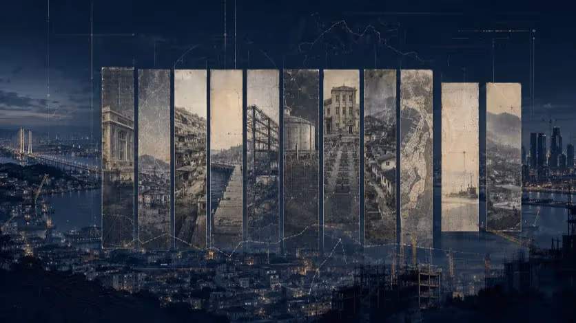
From Dadaepo to Hadan, the Gaps That Keep West Busan Off the Map
From industrial roads that cut off the riverfront to transit nodes that never became destinations, West Busan’s coastline is still shaped by planning decisions from the 1980s.


Busan, South Korea — West Busan holds assets that, on paper, could anchor a balanced urban and tourism strategy: Dadaepo’s expansive sunset beach, Eulsukdo’s ecological wetlands, and a riverside corridor along the Nakdonggang River.
Yet these locations remain fragmented, functioning as isolated destinations rather than parts of a connected urban network.
This summer’s Korea International Marine Leisure Week again demonstrated the limits of the current approach. For several days, Dadaepo filled with music, leisure sports, and promotional activity.
The event generated short-term crowds and media coverage—but no lasting change in visitor patterns, commercial activity, or nighttime economy. Once the programs ended, the area reverted to its baseline state of low footfall and limited services.
The underlying issue is structural. West Busan’s waterfront is still shaped by the industrial planning of the 1980s and 1990s, when freight mobility took precedence over pedestrian connectivity.
Key access points, such as Hadan, function as transit nodes without becoming destinations. Without integrated infrastructure and year-round activation, the city’s western districts risk remaining peripheral—visible in brochures, but marginal in lived experience.
How Industrial Planning Froze the Waterfront in Time
The disconnection along West Busan’s waterfront is not a recent oversight; it is the product of decades-old planning priorities.
In the 1980s and 1990s, South Korea’s rapid industrialization shaped these districts as functional zones for shipping, manufacturing, and logistics. Public access to the waterfront was secondary—sometimes explicitly restricted—to make room for industrial roads, port facilities, and flood-control infrastructure.
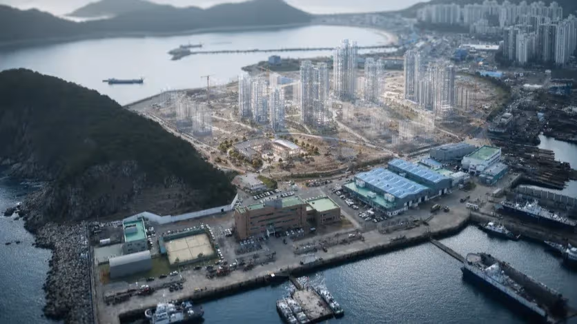
Gangseo-gu emerged as the city’s expansion frontier, with new industrial estates, port terminals, and logistics corridors oriented toward national and export markets. While this development strengthened Busan’s economic base, it produced large tracts of low-access, single-use land, physically separated from residential and leisure areas.
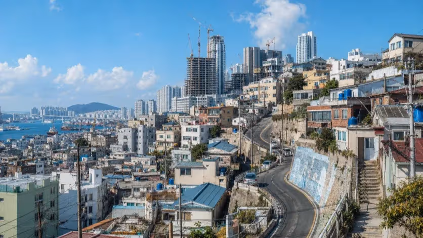
Saha-gu, despite its scenic coastline, saw much of its waterfront allocated to port-related functions and wide arterial roads designed for heavy vehicles. Tourism and public space planning were fragmented, leaving sites like Dadaepo and Eulsukdo as individual points of interest without a continuous pedestrian or cycling network between them.
Sasang-gu, positioned inland, became a logistics and manufacturing hub. Its rail yards and industrial estates created a physical barrier between the eastern and western districts. For travelers moving from central Busan to the western coast, Sasang is a bottleneck: essential for freight, but offering no incentives or amenities for pedestrian movement or tourism linkage.
The result is a tri-district western sector defined by functional isolation: Gangseo for industry, Saha for scattered tourism, Sasang for logistics. While each plays a role in Busan’s economy, their spatial and functional separation prevents the formation of an integrated urban and tourism corridor.
This inherited structure continues to dictate mobility patterns, investment flows, and the lived experience of residents and visitors alike.
When the Crowds Leave, the Streets Go Quiet
Event-driven surges in West Busan have become predictable in their rise and fall. When major programs such as the Korea International Marine Leisure Week take place, Dadaepo’s beach and adjacent streets swell with visitors. Social media activity spikes, temporary vendors do brisk business, and transport links into the area see short-lived crowding.
East vs West: Infrastructure & Usage
Yet these peaks are fleeting. Once the scheduled activities end, visitor numbers collapse, and the area returns to its baseline—low evening foot traffic, limited dining and retail options, and minimal overnight stays.
Accommodation supply illustrates the imbalance. Hotels and guesthouses are heavily concentrated in the eastern districts—Haeundae, Gwangalli, and central Busan—while West Busan offers a sparse inventory, often disconnected from waterfront attractions.
Without lodging near the sites, visitors default to day trips, spending only a few hours before returning east. This pattern keeps local nighttime economies weak and discourages the growth of supporting businesses.
Access & Continuity (West Busan)
Mobility between key sites remains fragmented. A visitor wishing to move from Hadan to Eulsukdo, or from Dadaepo to Macto, faces discontinuous pedestrian routes, indirect public transit options, and industrial road crossings designed for freight traffic rather than human-scale movement.
While the Nakdonggang River levee and the Galmaetgil trail system offer scenic potential, they function more as niche routes for locals than as intuitive connectors for first-time visitors.
Commercial activity suffers from this structural disconnect. Cafés, restaurants, and small shops cluster around immediate event zones but lack sustained patronage outside peak seasons.
In many streets, storefront turnover is high, and businesses that cater to transient visitors cannot rely on consistent demand. Nighttime lighting, signage, and wayfinding are inconsistent, further discouraging after-dark movement.
In effect, West Busan’s tourism pattern is one of points without corridors: attractive destinations that fail to reinforce each other because the connective framework—physical, economic, and cultural—remains underdeveloped.
Why the City Keeps Building Islands Instead of Bridges
The recurring pattern of short-lived visitor surges and long periods of inactivity is not merely the result of insufficient investment. It reflects a deeper misalignment in West Busan’s development approach: projects have been conceived as isolated interventions rather than as parts of an integrated urban system.
Municipal planning in the western districts has tended to focus on two recurring strategies: the creation of standalone attractions and the staging of high-profile events.
While each can produce temporary gains in visibility, neither addresses the foundational requirement for sustained urban vitality—continuous movement between sites, and reasons for people to stay.
The result is a “checklist” model of development, where success is measured by the completion of discrete projects rather than by the strength of the connections between them.
Hadan exemplifies this missed opportunity. As the natural gateway from central Busan to the western coastline, it holds the potential to serve as a primary gathering point, orientation hub, and cultural anchor.
Instead, it operates almost exclusively as a congested transfer point between bus, subway, and taxi lines, offering little in the way of public realm, commercial vibrancy, or direct pedestrian access to the waterfront.
This gap is compounded by governance fragmentation. Tourism promotion, transport planning, and urban design operate under separate mandates, often with limited coordination.
Academic research, municipal policy, and design consultancy tend to work in parallel rather than through a shared master framework. In practice, this means that a pedestrian bridge proposal, a waterfront event schedule, and a district redevelopment plan can all move forward without aligning on a single mobility or connectivity strategy.
Without re-centering policy on connectivity—both physical and programmatic—the western districts will remain a collection of individual sites, each with its own moment in the spotlight but no lasting place in the city’s daily life.
Hadan’s Untapped Role as the West Coast’s Front Door
Transforming Hadan from a congested transit node into a vibrant western gateway is essential if West Busan is to overcome its chronic disconnection. Geographically, Hadan occupies a rare position at the meeting point of Saha-gu, Sasang-gu, and the Nakdonggang River corridor, placing it directly on the path between the city’s established eastern core and its underdeveloped western shoreline.
Hadan: From Interchange to Starting Point
Yet in its present form, Hadan functions almost exclusively as a point of transfer, with its streets shaped by the logic of vehicle flow rather than human movement.
A serious reimagining of the district would start with the streets themselves, shifting the balance toward pedestrians and cyclists, opening visual and physical access to the river, and softening the industrial edge that now defines the area.
A continuous pedestrian link from Hadan to Eulsukdo—whether in the form of a dedicated bridge or an elevated walkway—would dissolve one of the most persistent barriers between inland neighborhoods and the waterfront.
Within Hadan, the creation of a civic plaza could anchor public life, bringing together information services, shaded seating, and flexible open space capable of hosting markets, cultural performances, or small-scale exhibitions throughout the year.
These physical changes would need to be matched by a programmatic reorientation. Rather than serving as a place people pass through, Hadan should become a place they begin their journey, linger, and return to.
That would require clustering dining, retail, and cultural venues in close proximity to transit exits, ensuring that arriving visitors find immediate reasons to stay. Clear, consistent wayfinding—designed to guide pedestrians toward the riverfront, Dadaepo, and other western attractions—would complete the sense of Hadan as an intuitive, accessible starting point.
By aligning its spatial design, commercial fabric, and cultural programming, Hadan could shift the logic of West Busan from one-off trips to interconnected itineraries.
Visitors drawn in by events at Dadaepo could just as easily find themselves exploring the wetlands of Eulsukdo or cycling along the Nakdonggang River, with Hadan acting as both the launchpad and the anchor for their experience.
In doing so, the district would not only elevate its own role but also bind together the fragmented assets of the entire western waterfront.
A City Governed in Silos Can’t Build a Connected Shoreline
The stagnation in West Busan’s waterfront development is as much a product of governance as it is of geography. Over the past two decades, the city’s western districts have been the subject of numerous announcements, promotional campaigns, and master plans, yet few have translated into sustained structural change.
The problem lies less in the absence of ideas than in the way those ideas are conceived, owned, and executed.
Municipal departments responsible for tourism, transport, and urban design often operate in parallel rather than in coordination. Tourism promotion strategies are devised without a detailed understanding of how visitors physically navigate the area, while transport upgrades are planned without integrating the destinations they are meant to serve.
Even when academic research or design consultancies are brought into the process, their contributions tend to remain compartmentalized, with no overarching framework to bind them together. In such an environment, it is possible for a waterfront event calendar, a pedestrian bridge proposal, and a residential redevelopment plan to advance simultaneously, yet fail to reinforce one another.
The city’s reliance on event-based activation reflects this fragmentation. High-profile festivals and seasonal programs can generate temporary attention, but without corresponding investment in year-round infrastructure, they serve more as publicity tools than as levers for systemic transformation.
The absence of a dedicated, cross-departmental entity empowered to align tourism, mobility, and urban space means that initiatives default to the jurisdiction of their respective departments, with limited incentive to address the gaps between them.
In the case of Hadan, this has produced a familiar pattern: transport planners see it as an interchange, tourism officials view it as peripheral to their primary attractions, and urban designers rarely treat it as a priority public realm project.
Without a governance structure that explicitly recognizes the interdependence of these perspectives, the area remains locked in its current role—a place to pass through, rather than a place to inhabit.
Designing for Movement, Not Just for the Map
Any serious attempt to reposition West Busan must begin with the principle that connectivity is not an accessory to development—it is its foundation. The physical fabric of the western districts was shaped during a period when industrial efficiency outweighed public accessibility, and the task now is to reverse that hierarchy without undermining the economic roles these areas still play.
Policy & Governance Checklist
This means that before new attractions are built or existing sites are refurbished, the routes that link them—whether on foot, by bicycle, or via public transit—must be continuous, legible, and inviting.
Redevelopment, too, must move beyond the parcel-by-parcel logic that has dominated recent urban renewal efforts. In waterfront and gateway districts such as Hadan, residential and commercial upgrades should be inseparable from public space improvements.
Streets that lead to the river must remain open and active, not blocked by walls of private development. This is not simply a matter of aesthetics, but of ensuring that each new investment strengthens the overall network of movement and experience rather than creating new pockets of isolation.
Ecological assets like the Nakdonggang River wetlands demand particular care. The impulse to “activate” such spaces for tourism must be balanced with their role as living ecosystems.
Low-impact design—boardwalks that hover above sensitive ground, lighting that minimizes disturbance, and programming that draws visitors without degrading the environment—can preserve these landscapes while making them accessible.
Ultimately, the measure of success will not be the number of festivals held or the scale of individual projects, but the degree to which the western waterfront feels like a single, navigable entity.
When a visitor can arrive in Hadan, spend the afternoon in Eulsukdo, watch the sunset at Dadaepo, and return without encountering dead zones or navigational confusion, West Busan will have moved from a patchwork of sites to a functioning urban coastline.
Building the First True Gateway
Turning West Busan from a collection of isolated destinations into an integrated waterfront district will require a shift not only in design and investment, but also in governance and execution.
The first step is to establish a single coordinating body with the authority to align tourism promotion, transport planning, and urban design within the western districts. Without such an entity, individual initiatives will continue to compete for attention and resources, with little incentive to address the spaces and connections between them.
From this central coordination point, projects should be sequenced to secure early wins in visibility and usability. Hadan’s transformation into a true gateway could serve as the pilot, signaling the city’s commitment to a connectivity-first approach.
This would entail simultaneous work on its public realm, commercial base, and direct pedestrian and cycling links to the Nakdonggang River corridor. By demonstrating tangible improvement in a single, high-impact node, the city could build public and investor confidence for broader interventions.
Financing should combine municipal budgets with targeted private-sector participation, particularly in the hospitality, retail, and cultural sectors. Yet participation must be guided by a master framework to prevent piecemeal, profit-driven development from eroding public access.
Regulatory tools—such as design guidelines, pedestrian access requirements, and incentives for ground-floor activation—can ensure that private investment strengthens rather than fragments the district’s connectivity.
Finally, evaluation must focus on lived experience rather than solely on economic output. Surveys, mobility tracking, and environmental monitoring should inform iterative adjustments, ensuring that the network of spaces evolves in response to how people actually use it.
In this way, West Busan’s development would move beyond the cycle of short-lived events and into a sustained pattern of daily life, where its waterfront is not simply visited, but inhabited.
Editorial Context
"Independent journalism relies on radical transparency. View our full log of editorial notes, corrections, and project dispatches in the Newsroom Transparency Log."
Reader Pulse
The report's impact signal
Be the first to provide a reading pulse. These collective signals help our newsroom understand the impact of our reporting.
Join the discussion
A more thoughtful conversation, anchored to the story
Atlantic-style discussion for this article. One-level replies, editor prompts, and moderation-first participation are now powered directly by Prisma.
Discussion Status
Open
Please sign in to join the discussion.
The Weekly Breeze
Independent reporting and analysis on Busan,
Korea, and the broader regional economy.