Busan’s ‘15-Minute City’ Map: Policy Tool or Just Digital Window Dressing?
Busan’s new Life Map promises to bring “15-minute city” convenience to residents, but its current features barely go beyond existing commercial map apps.


Busan, South Korea — Busan City has been promoting its “15-Minute City” policy as a flagship vision for urban living, presenting it as a model tailored to the city’s geography and lifestyle. The promise is that residents should be able to access essential facilities—whether for daily life, work, health, education, or leisure—within a short walk or ride.
This month, officials unveiled the “15-Minute City Life Map,” a website that lists 1,665 facilities in ten categories, from libraries and parks to sports and cultural centers. The site is open to the public without registration, offers keyword and category searches, and displays each facility on a KakaoMap view.
The announcement came with confident language about accessibility, convenience, and community well-being. But beneath the branding, a more fundamental question emerges: is Busan actually defining the 15-minute city in a way that meets the concept’s original intent, or has it reduced it to a matter of building and cataloging SOC facilities while calling the result “innovation”?
The map’s launch, rather than revealing a new urban structure, seems to show a repackaging of existing assets.
The 15-minute city model, first articulated in Paris, is a time-based measure of accessibility. It asks whether people can reach schools, health care, shops, and public spaces within a fixed travel time on foot or by bicycle, supported by integrated transport, mixed-use planning, and safe public realm design.
In Paris and other cities, it has involved redesigning streets to slow cars and make room for pedestrians, shifting public services into neighborhoods, and tracking results through measurable indicators. By comparison, Busan’s current approach is to divide the city into 62 “living zones” and ensure each zone has certain categories of facilities—without yet demonstrating whether residents can reach them within the promised time, especially given the city’s formidable terrain.
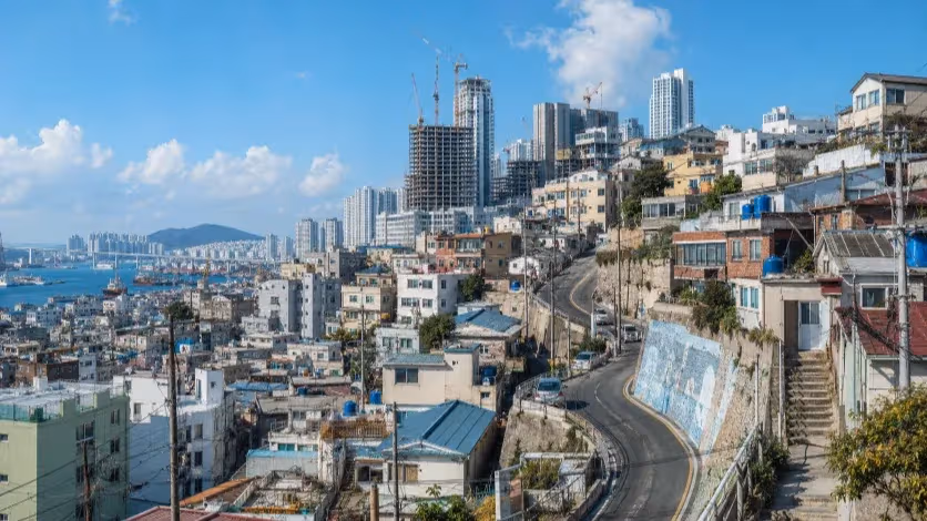
Geography is the first constraint. Nearly half of Busan’s land is mountainous, with steep gradients, ridgelines, and coastal inlets fragmenting neighborhoods. A facility may be well within the 750-meter theoretical radius, but in reality a 15-minute walk could involve long stair climbs, detours, or unsafe crossings.
The city itself acknowledges that slopes, retaining walls, and elevation differences physically limit walking accessibility. It has floated ideas for overcoming these barriers—such as vertical lifts, micromobility options, and shared mobility services—but these remain largely conceptual. For now, the Life Map shows points on a map, not the means to traverse the obstacles between them.
This gap between theory and implementation has led some observers to see the policy as more branding than structural reform. Instead of tackling the problem of physical connectivity, the city appears to have focused on building and renovating community centers, cultural halls, and sports facilities, then framing these projects as milestones in its 15-minute strategy.
Such facilities have value in themselves, but without a transport and access plan that links them to the daily movements of residents, they function as static assets—good for ribbon-cuttings and annual reports, but less transformative in practice.
Public recognition of the initiative remains modest. In a recent city poll, fewer than four in ten residents said they were aware of the 15-minute city policy. Overall satisfaction with municipal programs has fallen below half.
This contrasts with other policies—such as improvements to the integrated public transport system—that enjoy awareness levels above 60 percent. The figures suggest that the 15-minute city has yet to resonate as a lived reality, and may be seen by many as a slogan rather than a service.
International comparisons make the differences clearer. In Barcelona, the creation of “superblocks” reorganized street grids to prioritize pedestrians and cyclists, producing measurable improvements in air quality and public space use.
In Hong Kong, the Central–Mid-Levels escalator system directly connects hillside neighborhoods to the central business district, cutting travel times and removing physical barriers.
In both cases, the change was physical, not just informational. Guangzhou’s planners, likewise, have tied their 15-minute program to density, transit orientation, and public space redesign—linking facility provision to the lived patterns of residents, rather than to construction counts alone.
Busan’s emphasis on SOC provision without a parallel strategy for movement risks reinforcing existing inequalities in access. In neighborhoods where facilities are plentiful but poorly connected, the people who benefit most will be those who already have private transport.
For older residents, who make up nearly a quarter of the population, the lack of step-free routes, safe crossings, and clear wayfinding means that “nearby” can remain functionally distant. Without barrier-free paths, the city’s most vulnerable are left out of its own vision.
The absence of performance metrics compounds the problem. A credible 15-minute city policy would publish data on the percentage of residents who can reach key facilities within the target time, disaggregated by age, mobility status, and district.
It would identify gaps and set timelines for closing them. Instead, Busan’s program offers no such benchmarks, making it impossible to assess progress or hold the administration accountable for results.
The Life Map, in its current form, is little more than a curated list of facility locations displayed through a KakaoMap interface—something users could already find with existing commercial map services. It lacks the analytical functions that would give meaning to the “15-minute city” label, such as calculating actual travel times, mapping step-free or accessible routes, integrating public transport schedules, or identifying neighborhoods with poor connectivity.
Without these capabilities, the tool operates as an online directory rather than a genuine accessibility platform. For it to serve the policy’s stated purpose, the city would need to treat it not as a finished product but as the entry point to a broader, data-driven program aimed at overcoming Busan’s steep terrain and fragmented urban fabric.
Until that shift happens, the initiative risks being remembered less as a model of proximity and more as a case study in how an appealing urban vision can be reduced to a branding exercise—polished in presentation but thin in practical impact.
Editorial Context
"Independent journalism relies on radical transparency. View our full log of editorial notes, corrections, and project dispatches in the Newsroom Transparency Log."
Reader Pulse
The report's impact signal
Be the first to provide a reading pulse. These collective signals help our newsroom understand the impact of our reporting.
Join the discussion
A more thoughtful conversation, anchored to the story
Atlantic-style discussion for this article. One-level replies, editor prompts, and moderation-first participation are now powered directly by Prisma.
Discussion Status
Open
Please sign in to join the discussion.
The Weekly Breeze
Independent reporting and analysis on Busan,
Korea, and the broader regional economy.